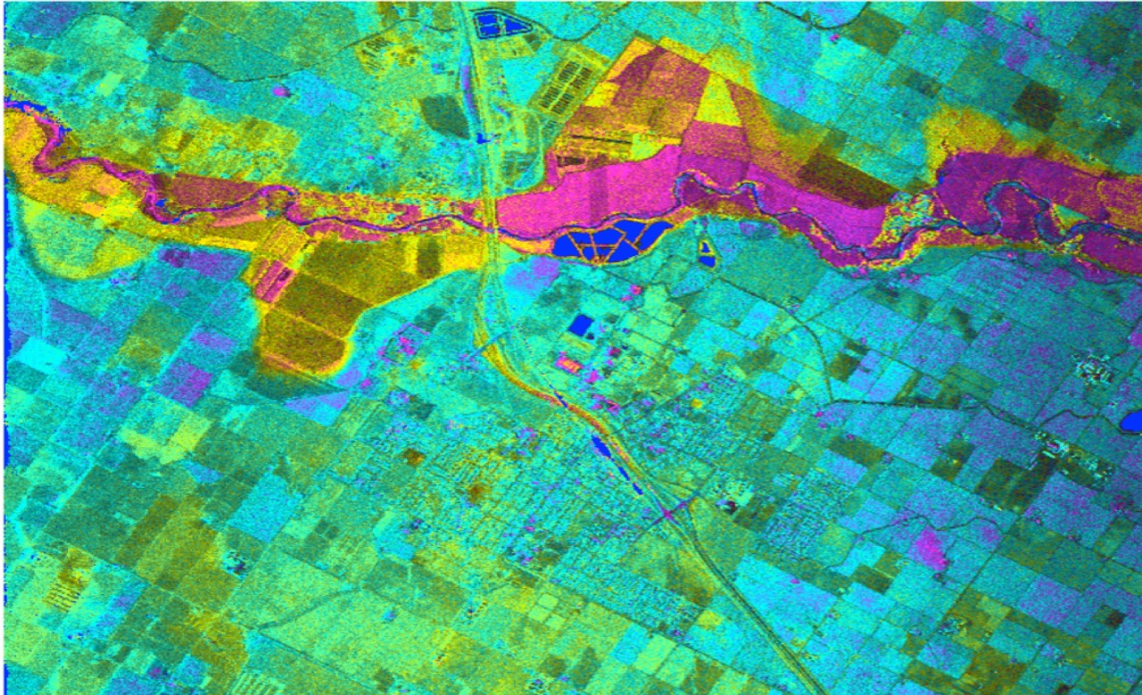
Over 10 years we help companies reach their financial and branding goals. Engitech is a values-driven technology agency dedicated.

Gallery

Contacts

411 University St, Seattle, USA

contactus@lucidpath.io

+1 -800-456-478-23

Remote Sensing

Get unlimited access to our top-quality and professional Remote sensing services.

Best remote sensing services to various businesses despite size and industry

Remote sensing is the process of detecting and observing the physical characteristics of a particular area by calculating its reflected and emitted radiation at a distance. Remote sensing data conversion is very crucial for every business as it helps companies collect data over large spatial areas from various places on the ground, which includes areas that are difficult to reach physically. Lucidpath’s remote sensing services help you semantically monitor surface areas and objects. Our expertise helps you implement it in your business effectively through the guidance of expert professionals who take ownership of the whole data acquisition process. With the usage of satellites, airplanes, etc., data can be captured easily, quickly, and accurately. We offer cost-effective remote sensing services like image classification, image processing, change detection, etc. for various businesses.

Boost your business with Lucidpath’s Remote sensing services

Through industrially compliant remote sensing services at Lucidpath, businesses have an added advantage in mapping projects. They maintain a high accuracy level in data collection, which is a very important input for planning and designing any mapping project. We have powerful hardware to store huge volumes of data sets, such as terabyte servers, dual processors, etc., which boosts your business, especially when there is the processing of larger geographical areas. Our expertise in remote sensing software such as QGIS, ArcGis, SAGA Gis, etc. helps in the easy implementation of this methodology. Any business can avail itself of key benefits of remote sensings, such as faster data collection and analysis than an on-site collection of data. Businesses can use the information obtained from a remotely sensed image extensively and for different purposes depending on their business requirements. We are a one-stop solution for all queries and activities regarding remote sensing along with GIS mapping technology that makes your business successful undoubtedly.

Our remote sensing services include

01
Image Classification
It is a process of extracting information classes from multiband raster images. It helps to create thematic maps. Our expertise lies in both supervised and unsupervised image classification. We help in remote sensing data collection from resources like satellite image processing, aerial photography, etc.
02
Image Processing
It is a process to perform a few operations on a certain image, either to improve its quality or extract valuable information from it. We are vastly experienced in various image processing procedures, especially formatting and correcting data, image compression, image restoration, etc.
03
Change Detection
This is a very important aspect of remote sensing as it helps to compare and critically analyze two or more remote sensing images taken through a satellite image resource at different times in the same region and extract different information about the ground object or image. It helps various businesses, and it plays a role in non-commercial use as well.

Why choose remote sensing?

High accuracy

One of the key advantages of choosing remote sensing is its high accuracy, which helps companies refer to an accurate outcome and use data effectively. This helps with more accurate research that helps companies use the data wisely, which helps businesses grow and gain revenue.

Data usage repetition

It enables companies to use data repetitively for various purposes. The acquired data obtained from remote sensing is stored in databases and used whenever required.

Time-saving technique

Compared to other techniques, remote sensing is time-saving, as companies can collect large volumes of data accurately and swiftly by using satellites and flying devices together.

Data usage in real-time

Data acquired from remote sensing can be used in real-time to make close predictions. Many organizations, especially those who work on predicting natural calamities, the environment sector, etc., can use this technique effectively and identify those areas that require evacuation before the situation goes out of control.

Large area coverage

It allows large area coverage, which helps businesses by enabling regional surveys on different themes and extremely large feature identification.

Why Should You Choose Lucidpath’s Remote sensing Services

Our years of expertise, experience, and proven track records ensure your business remains on top of every competition, always.

Customer satisfaction

Lucidpath has all the expertise, resources, and tools necessary to deliver top-quality, professional GIS mapping services to clients that assure 100% customer satisfaction.

Expertise Driven By Experience

You will be working with an elite group of professionals who are certified and have extensive expertise in this field.

One-stop shop

Lucidpath is a one-stop shop for any activity or query related to remote sensing services that are required for your business, as we have deep expertise and vast experience we acquire by handling clients regularly.

Cost-effective

We offer rich-quality remote sensing services at affordable prices that help your business make the most of the map’s data, which helps in the proper usage of a property or land, etc.

Effective data management

Our team of expert professionals helps in effective data management that improves the reliability, scalability, and performance of your business as we help in using the data wisely and at the right places, as data is key for any business.

No quality compromise

Lucidpath will never compromise on the quality of its remote sensing services, as our main aim is to deliver the best for our customers.

// latest case studies

Case Studies

Software development outsourcing is just a tool to achieve business goals. But there is no way
to get worthwhile results without cooperation and trust between a client company.

Accelerate Business Growth with Lucidpath

Lucidpath’s remote sensing services improve business efficiency and increase ROI through precise data collection and analysis. We also play a key role in the expansion of your business. Hire remote sensing experts from Lucidpath to avail yourself of the benefits of this service.
Bespoke Remote Sensing Service With Precise Business Outcomes

Let's Forge A Path Forwards Together